Introduction
"Every city has a unique road texture, as distinctive as a fingerprint."
This is Part 15 of the "Open Source Project of the Day" series. Today we explore MapToPoster (GitHub).
Have you ever thought about converting a city you love into a beautiful poster? MapToPoster makes this idea a reality. It uses OpenStreetMap's open-source map data and Python code to convert city road networks into minimalist-style beautiful poster designs. Whether it's Paris's romantic streets, Tokyo's dense road networks, or New York's grid layout — all can be transformed into unique works of art.
Why this project?
- 🗺️ Real map data: Based on OpenStreetMap, data is accurate and free
- 🎨 17 beautiful themes: From minimalist black-and-white to neon cyberpunk, satisfying all aesthetics
- 🐍 Pure Python implementation: Clean code, easy to understand and customize
- 🎯 Minimalist design: Focused on road textures to reveal each city's unique beauty
- 📐 Flexible configuration: Supports custom distance, coordinates, fonts, themes, and more
- 🌍 Global city support: Supports road networks for any city in the world
What You'll Learn
- MapToPoster's core principles and architectural design
- How to use OSMnx to get and process map data
- The design philosophy and use cases for 17 themes
- How to customize themes and styles
- Font management and Google Fonts integration
- Layer structure and optimization tips for map rendering
- Best practices and parameter tuning in real usage
Prerequisites
- Basic Python syntax and command-line usage
- Basic understanding of maps and geographic data
- Familiarity with JSON configuration file format
- Basic concepts of data visualization (optional, helps understand rendering principles)
Project Background
Project Introduction
MapToPoster is a Python tool for converting city maps into beautiful posters with code. It uses OpenStreetMap's open-source map data and the OSMnx library to retrieve city road networks, then renders them into minimalist-style poster designs using matplotlib. You can choose different themes, adjust the distance range, customize fonts, and generate unique city map posters.
Core problems the project solves:
- Lack of simple and easy-to-use map poster generation tools
- Commercial map service APIs are expensive and restricted
- Need a programmable, customizable map visualization solution
- Desire to convert city maps into works of art
- Need to batch generate map posters for different cities and themes
Target user groups:
- Designers and artistic creators
- Geographic data visualization enthusiasts
- Python developers
- Urban planning and architecture professionals
- Users who want to create personalized city posters
Author/Team Introduction
Author: originalankur
- Background: Open-source contributor focused on data visualization and design tools
- Project creation date: 2024 (based on GitHub activity, an actively maintained project)
- Philosophy: Create beauty with code, turn map data into art
- Tech stack: Python, OSMnx, matplotlib, OpenStreetMap
Project Stats
- ⭐ GitHub Stars: 9.8k+ (rapidly and continuously growing)
- 🍴 Forks: 872+
- 📦 Version: Continuously updated (50+ commits)
- 📄 License: MIT (fully open source, free to use)
- 🌐 Project: GitHub
- 💬 Community: Active GitHub Issues, 9 open Issues, 16 Pull Requests
- 👥 Contributors: 15 contributors, active community participation
Project development history:
- 2024: Project created, core features implemented
- Mid-2024: Added multi-theme support
- Late 2024: Improved font management and Google Fonts integration
- 2025: Optimized rendering performance, added more themes
- Ongoing maintenance: Project remains active with continuous community contributions
Main Features
Core Purpose
MapToPoster's core purpose is to convert city map data into beautiful poster designs, with main features including:
- Map data acquisition: Uses OSMnx to retrieve city road network data from OpenStreetMap
- Multi-theme rendering: Supports 17 carefully designed themes, from minimal to cyberpunk
- Flexible configuration: Supports custom distance range, center coordinates, fonts, themes, and more
- High-quality output: Generates high-resolution PNG images suitable for printing and display
- Font management: Supports local fonts and automatic Google Fonts download
- Script detection: Automatically detects text script (Latin/non-Latin) and applies appropriate typography
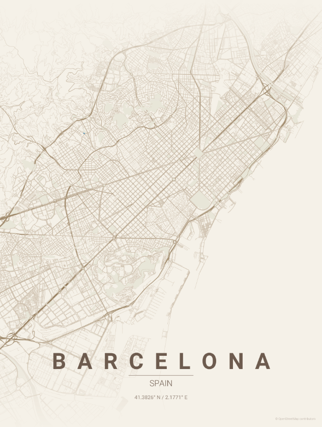
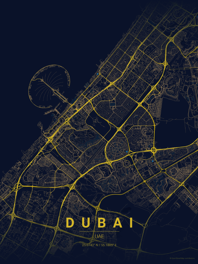
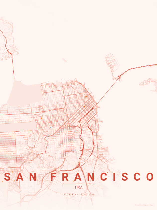
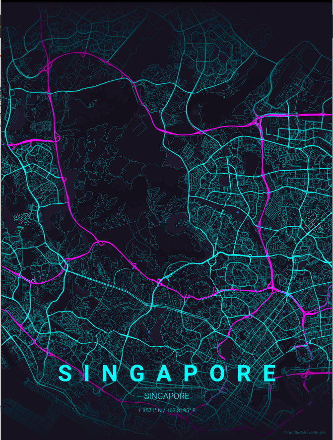
Use Cases
MapToPoster is suitable for multiple scenarios:
-
Personal collection and decoration
- Create city map posters of places you've lived or love
- Use as room decoration or give as gifts to friends
- Document your travel footprint with a city series of posters
-
Design and artistic creation
- Designers obtaining city map materials
- Map elements for art projects
- Geographic elements in brand design
-
Education and display
- Visualization tool for geography teaching
- Urban planning presentations
- Data visualization projects
-
Batch generation
- Generate consistent-style posters for multiple cities
- Test different theme effects
- Create city comparison series
Quick Start
Installation
MapToPoster installation is very simple:
# 1. Clone the project
git clone https://github.com/originalankur/maptoposter.git
cd maptoposter

# 2. Install dependencies
pip install -r requirements.txt

# Or use pyproject.toml
pip install -e .
Main dependencies:
osmnx: Get OpenStreetMap datamatplotlib: Map renderinggeopy: Geocoding (via Nominatim)requests: Google Fonts API calls
Simplest Usage Example
Generate a minimalist black-and-white style poster of Paris:
python create_map_poster.py -c "Paris" -C "France" -t noir -d 10000This command will:
- Find Paris's coordinates (via Nominatim geocoding)
- Retrieve the road network within a 10km radius
- Use the
noirtheme (pure black background, white roads) - Generate the poster and save it to the
posters/directory
Output filename format: Paris_noir_20260208_143022.png
Common Command Examples
# Generate posters with different themes
python create_map_poster.py -c "Tokyo" -C "Japan" -t neon_cyberpunk -d 15000
python create_map_poster.py -c "London" -C "UK" -t noir -d 15000
python create_map_poster.py -c "New York" -C "USA" -t blueprint -d 12000

# Use custom coordinates
python create_map_poster.py --city "Shanghai" --country "China" \
  -lat 31.2304 -long 121.4737 -t sunset -d 10000

# View all available themes
python create_map_poster.py --list-themes

# Generate all themes for the same city
python create_map_poster.py -c "Paris" -C "France" --all-themes -d 10000
Core Features
MapToPoster's core features include:
-
17 beautiful themes
- From minimalist black-and-white (noir) to neon cyberpunk (neon_cyberpunk)
- Each theme has a unique color scheme and design philosophy
- Supports custom theme JSON files
-
Intelligent road classification
- Automatically classifies based on OSM's highway tag
- Different road grades use different colors and widths
- Presents a clear road hierarchy
-
Flexible distance control
- Supports distance ranges from 4000m to 20000m+
- Recommends appropriate distances based on city scale
- Balances detail and overall effect
-
Font management
- Uses Roboto font by default
- Supports automatic Google Fonts download
- Automatically detects text script, applies appropriate typography
-
High-quality rendering
- Default 300 DPI, suitable for printing
- Supports custom DPI settings
- Optimized rendering performance
-
Geocoding integration
- Automatically finds city coordinates via Nominatim
- Supports city name + country name combination
- Supports directly specifying latitude/longitude coordinates
Project Advantages
Compared to other map visualization tools:
| Comparison | MapToPoster | Google Maps API | Mapbox | Other Open Source |
|---|---|---|---|---|
| Cost | Completely free | Pay per use | Pay per use | Free but limited |
| Data source | OpenStreetMap (open) | Google proprietary | Mapbox proprietary | Various sources |
| Customizability | Highly customizable | Limited | Moderate | Usually low |
| Theme support | 17 beautiful themes | Limited styles | Requires design | Usually none |
| Code control | Fully programmable | API calls | API calls | Partially programmable |
| Output quality | High-res PNG | Requires processing | Requires processing | Usually low |
| Offline use | Supported (needs caching) | Not supported | Not supported | Partial support |
Why choose MapToPoster?
- ✅ Completely free: Based on open-source data, no API fees
- ✅ Highly customizable: Open-source code, can modify any detail
- ✅ Beautiful themes: 17 professionally designed themes, ready to use
- ✅ Simple to use: A single command generates a poster
- ✅ High-quality output: High-resolution images suitable for printing and display
- ✅ Active community: 9.8k+ Stars, continuously updated and maintained
Detailed Project Analysis
Architecture Design
MapToPoster's overall architecture is very clear, consisting of the following modules:
┌─────────────────┐     ┌──────────────┐     ┌─────────────────┐
│   CLI Parser    │────▶│  Geocoding   │────▶│  Data Fetching  │
│   (argparse)    │     │  (Nominatim) │     │    (OSMnx)      │
└─────────────────┘     └──────────────┘     └─────────────────┘
                                                     │
                        ┌──────────────┐             ▼
                        │    Output    │◀────┌─────────────────┐
                        │  (PNG File)  │     │   Rendering     │
                        └──────────────┘     │  (matplotlib)   │
                                             └─────────────────┘
Core process:
- Command-line parsing: Uses
argparseto parse user input (city, theme, distance, etc.) - Geocoding: Converts city names to lat/lon coordinates via Nominatim API
- Data fetching: Uses OSMnx to get road network data from OpenStreetMap
- Theme loading: Loads theme configuration from JSON files
- Map rendering: Uses matplotlib to render the map according to theme configuration
- File saving: Saves the rendered result as a PNG file
Core Module Analysis
1. Geocoding Module
MapToPoster uses Nominatim (OpenStreetMap's geocoding service) to find city coordinates:
# Core function: get_coordinates()
# Input: city name, country name
# Output: lat/lon coordinates

# Example call
coordinates = get_coordinates("Paris", "France")
# Returns: (48.8566, 2.3522)Characteristics:
- Free to use, no API key required
- Supports city name + country name combination for improved accuracy
- Supports directly specifying lat/lon to skip geocoding
2. Data Fetching Module (OSMnx)
OSMnx is MapToPoster's core dependency for getting OpenStreetMap data:
# Core function: Get road network
import osmnx as ox

# Get road network from point coordinates
G = ox.graph_from_point(
    point=(lat, lon),
    dist=distance,      # Distance (meters)
    network_type='drive'  # Road type
)

# Get water and park data
water = ox.features_from_point(
    point=(lat, lon),
    tags={'natural': 'water'},
    dist=distance
)
parks = ox.features_from_point(
    point=(lat, lon),
    tags={'leisure': 'park'},
    dist=distance
)
Data layers:
- Road network: Different road grades (motorway, primary, secondary, tertiary, residential)
- Water bodies: Rivers, lakes, and other water features
- Parks: Green spaces, parks, and other areas
3. Theme System
MapToPoster's theme system is very flexible — each theme is a JSON file:
{
  "name": "Noir",
  "description": "Pure black background, white roads",
  "bg": "#000000",
  "text": "#FFFFFF",
  "gradient_color": "#000000",
  "water": "#1A1A1A",
  "parks": "#0A0A0A",
  "road_motorway": "#FFFFFF",
  "road_primary": "#F0F0F0",
  "road_secondary": "#E0E0E0",
  "road_tertiary": "#D0D0D0",
  "road_residential": "#C0C0C0",
  "road_default": "#D0D0D0"
}
Theme configuration options:
bg: Background colortext: Text colorwater: Water body colorparks: Park colorroad_*: Colors for different road grades
Overview of 17 themes:
| Theme Name | Style Description | Use Case |
|---|---|---|
noir | Pure black background, white roads | Minimalist, modern style |
midnight_blue | Deep blue background, gold roads | Elegant, business style |
blueprint | Architectural blueprint style | Architecture, engineering theme |
neon_cyberpunk | Neon cyberpunk | Tech, futuristic |
gradient_roads | Gradient road coloring | Artistic, creative |
contrast_zones | High-contrast urban density | Emphasizes city structure |
warm_beige | Vintage brown tones | Nostalgic, retro style |
pastel_dream | Soft pastel colors | Soft, dreamy |
japanese_ink | Japanese ink wash style | Eastern aesthetics |
emerald | Emerald green tones | Natural, ecological |
forest | Deep green and sage | Natural, forest theme |
ocean | Blue and cyan | Coastal cities |
terracotta | Mediterranean warm tones | Mediterranean style |
sunset | Warm orange and pink | Warm, romantic |
autumn | Autumn leaf orange-red | Seasonal theme |
copper_patina | Oxidized copper aesthetics | Industrial, metallic |
monochrome_blue | Monochrome blue palette | Unified, clean |
4. Rendering System
MapToPoster's rendering system uses matplotlib, rendering in a specific layer order:
Render layers (z-order):
z=11  Text labels (city name, country name, coordinates)
z=10  Gradient masks (top and bottom gradient effects)
z=3   Road network (via ox.plot_graph)
z=2   Parks (green polygons)
z=1   Water bodies (blue polygons)
z=0   Background color
Road grade rendering:
# Set colors and widths based on road type
def get_edge_colors_by_type(edge_types, theme):
    colors = []
    for edge_type in edge_types:
        if 'motorway' in edge_type:
            colors.append(theme['road_motorway'])
        elif 'primary' in edge_type or 'trunk' in edge_type:
            colors.append(theme['road_primary'])
        elif 'secondary' in edge_type:
            colors.append(theme['road_secondary'])
        elif 'tertiary' in edge_type:
            colors.append(theme['road_tertiary'])
        elif 'residential' in edge_type:
            colors.append(theme['road_residential'])
        else:
            colors.append(theme['road_default'])
    return colors
Road width grades:
motorway, motorway_link: Thickest (1.2), darkest colortrunk, primary: Thick (1.0)secondary: Medium (0.8)tertiary: Thin (0.6)residential, living_street: Thinnest (0.4), lightest color
5. Font Management System
MapToPoster includes an intelligent font management system:
Font loading logic:
- Prioritize local fonts (from
fonts/directory) - If not available locally, download from Google Fonts
- Automatically cache downloaded fonts to
fonts/cache/directory
Script detection:
- Automatically detects if text uses Latin script
- Latin script: Apply letter spacing, producing "P A R I S" effect
- Non-Latin script (Chinese, Japanese, Arabic, etc.): Use natural spacing
def is_latin_script(text):
    """Detect if text uses Latin script"""
    latin_chars = sum(1 for c in text if '\u0000' <= c <= '\u024F')
    total_chars = sum(1 for c in text if c.isalpha())
    return (latin_chars / total_chars) > 0.8 if total_chars > 0 else False
Advanced Customization Tips
1. Create Custom Themes
Creating a custom theme is simple — just create a JSON file in the themes/ directory:
// themes/my_custom_theme.json
{
  "name": "My Custom Theme",
  "description": "A custom theme with warm colors",
  "bg": "#2C1810",
  "text": "#F5E6D3",
  "gradient_color": "#2C1810",
  "water": "#1A4A5C",
  "parks": "#3A5A3A",
  "road_motorway": "#E8B86D",
  "road_primary": "#D4A574",
  "road_secondary": "#C0956A",
  "road_tertiary": "#AD8560",
  "road_residential": "#9A7556",
  "road_default": "#AD8560"
}
Then use it:
python create_map_poster.py -c "Paris" -C "France" -t my_custom_theme -d 100002. Batch Generation Script
#!/usr/bin/env python3
# batch_generate.py

import subprocess

cities = [
    ("Paris", "France", "noir", 10000),
    ("Tokyo", "Japan", "neon_cyberpunk", 15000),
    ("New York", "USA", "blueprint", 12000),
    ("London", "UK", "midnight_blue", 10000),
]

for city, country, theme, distance in cities:
    print(f"Generating {city} with {theme} theme...")
    cmd = [
        "python", "create_map_poster.py",
        "-c", city,
        "-C", country,
        "-t", theme,
        "-d", str(distance)
    ]
    subprocess.run(cmd)
    print(f"✓ Completed {city}\n")
Project Resources
Official Resources
Who Should Use This
MapToPoster is suitable for:
-
Designers and artistic creators
- Designers needing city map materials
- Artists creating city-themed works
- Creative workers who need to batch generate map designs
-
Python developers
- Developers interested in data visualization
- Programmers wanting to learn geographic data processing
- Developers needing to integrate maps into projects
-
Geographic and urban planning professionals
- Urban planners and architects
- Geographic Information System (GIS) workers
- Professionals who need to showcase city structures
-
General users
- Users wanting to create personalized city posters
- Travelers documenting their journeys
- Map and geographic data enthusiasts
-
Educators
- Geography teachers needing visualization tools
- Teaching materials for data visualization courses
- Project materials for programming and design courses
Welcome to visit my personal homepage for more useful knowledge and interesting products